|
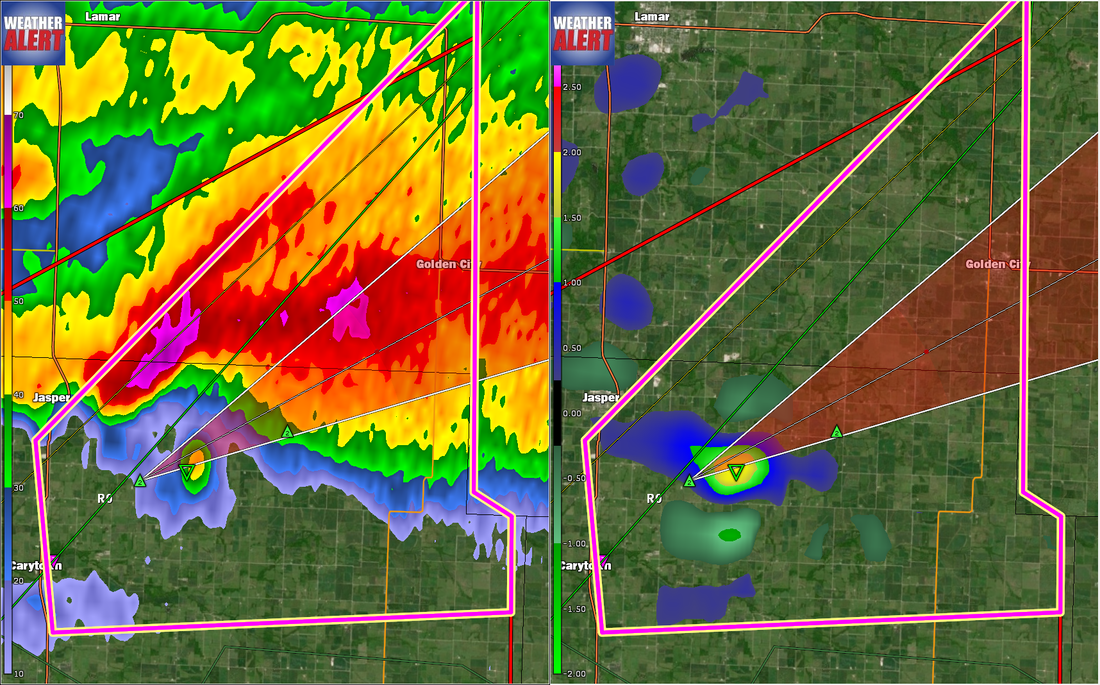
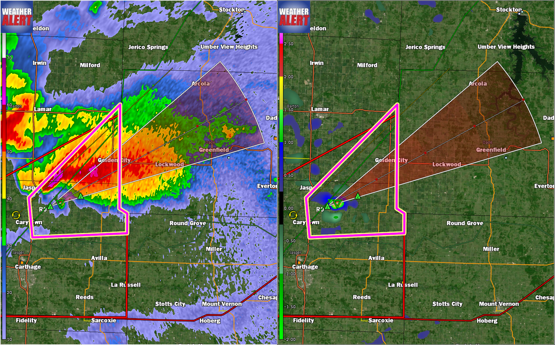
...A TORNADO WARNING REMAINS IN EFFECT UNTIL 915 PM CDT FOR SOUTHEASTERN BARTON AND NORTHEASTERN JASPER COUNTIES... At 850 PM CDT, a large and extremely dangerous tornado was located near Jasper, or 9 miles northeast of Carthage, moving northeast at 35 mph. This is a PARTICULARLY DANGEROUS SITUATION. TAKE COVER NOW! HAZARD...Damaging tornado. SOURCE...Radar indicated rotation. IMPACT...You are in a life-threatening situation. Flying debris may be deadly to those caught without shelter. Mobile homes will be destroyed. Considerable damage to homes, businesses, and vehicles is likely and complete destruction is possible. Locations impacted include... Jasper... Golden City... Maple Grove... Dudenville... This includes Interstate 49 between mile markers 52 and 54. PRECAUTIONARY/PREPAREDNESS ACTIONS... To repeat, a large, extremely dangerous and potentially deadly tornado is developing. To protect your life, TAKE COVER NOW! Move to a basement or an interior room on the lowest floor of a sturdy building. Avoid windows. If you are outdoors, in a mobile home, or in a vehicle, move to the closest substantial shelter and protect yourself from flying debris. && LAT...LON 3732 9431 3751 9408 3730 9408 3729 9406 3725 9406 3724 9430 TIME...MOT...LOC 0150Z 240DEG 31KT 3730 9423 TORNADO...RADAR INDICATED TORNADO DAMAGE THREAT...CONSIDERABLE HAIL...2.00IN
0 Comments
...TORNADO EMERGENCY FOR AREAS NEAR ORONOGO... ...A TORNADO WARNING REMAINS IN EFFECT UNTIL 845 PM CDT FOR WESTERN JASPER COUNTY... At 818 PM CDT, a confirmed large and destructive tornado was located over Oronogo, or near Joplin, moving northeast at 25 mph. TORNADO EMERGENCY for areas near Oronogo. This is a PARTICULARLY DANGEROUS SITUATION. TAKE COVER NOW! HAZARD...Deadly tornado. SOURCE...Radar confirmed tornado. IMPACT...You are in a life-threatening situation. Flying debris may be deadly to those caught without shelter. Mobile homes will be destroyed. Considerable damage to homes, businesses, and vehicles is likely and complete destruction is possible. Locations impacted include... Northern Joplin... Carthage... Webb City... Carl Junction... Oronogo... Carterville... Airport Drive... Alba... Purcell... Carytown... Brooklyn Heights... This includes Interstate 49 between mile markers 40 and 44. PRECAUTIONARY/PREPAREDNESS ACTIONS... To repeat, a large, extremely dangerous, and potentially deadly tornado is on the ground. To protect your life, TAKE COVER NOW! Move to an interior room on the lowest floor of a sturdy building. Avoid windows. If in a mobile home, a vehicle or outdoors, move to the closest substantial shelter and protect yourself from flying debris. && LAT...LON 3714 9454 3719 9454 3730 9434 3712 9432 TIME...MOT...LOC 0118Z 242DEG 23KT 3718 9450 TORNADO...OBSERVED TORNADO DAMAGE THREAT...CATASTROPHIC HAIL...2.50IN 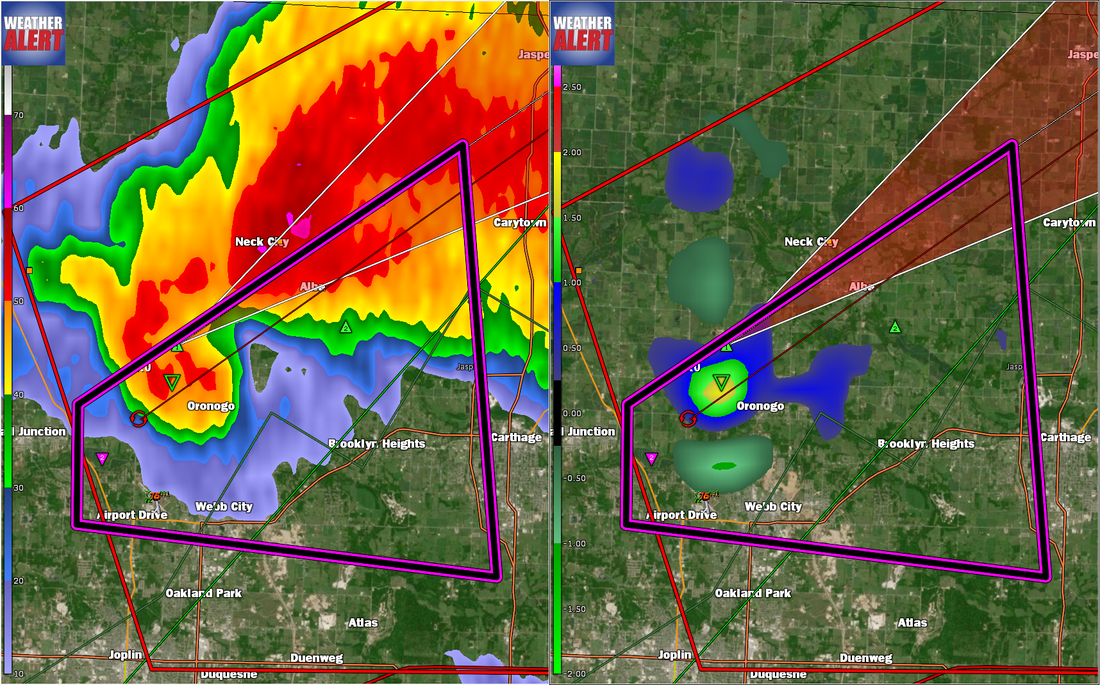 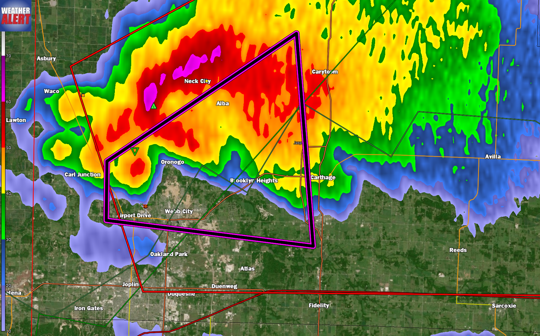 BULLETIN - EAS ACTIVATION REQUESTED Tornado Warning National Weather Service Springfield MO 754 PM CDT Wed May 22 2019 The National Weather Service in Springfield has issued a * Tornado Warning for... Southeastern Cherokee County in southeastern Kansas... Northwestern Newton County in southwestern Missouri... Western Jasper County in southwestern Missouri... * Until 845 PM CDT. * At 753 PM CDT, a confirmed tornado was located over Galena, or near Baxter Springs, moving east at 25 mph. HAZARD...Damaging tornado and hail up to two inches in diameter. SOURCE...Weather spotters confirmed tornado. IMPACT...Flying debris will be dangerous to those caught without shelter. Mobile homes will be damaged or destroyed. Damage to roofs, windows, and vehicles will occur. Tree damage is likely. * Locations impacted include... Joplin... Carthage... Webb City... Carl Junction... Baxter Springs... Galena... Oronogo... Carterville... Duquesne... Duenweg... Airport Drive... Leawood... Lowell... Silver Creek... Alba... Purcell... Shoal Creek Drive... Saginaw... Carytown... Fidelity... This includes the following highways... Interstate 44 between mile markers 6 and 18. Interstate 49 between mile markers 33 and 36, and between mile markers 40 and 44. PRECAUTIONARY/PREPAREDNESS ACTIONS... To repeat, a tornado is on the ground. TAKE COVER NOW! Move to a basement or an interior room on the lowest floor of a sturdy building. Avoid windows. If you are outdoors, in a mobile home, or in a vehicle, move to the closest substantial shelter and protect yourself from flying debris. && LAT...LON 3701 9472 3710 9472 3730 9434 3702 9430 TIME...MOT...LOC 0053Z 253DEG 20KT 3707 9469 TORNADO...OBSERVED HAIL...2.00IN 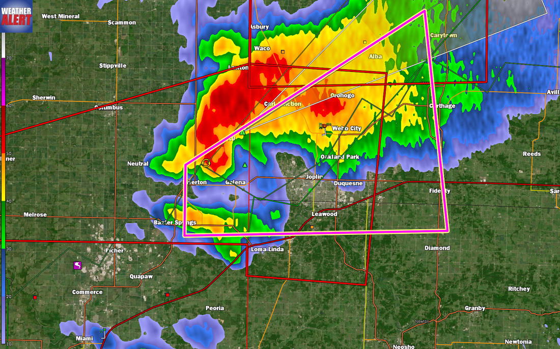 |
| FenAlert Weather |
|
 RSS Feed
